• Contact
    • AOI
    • Google Earth
    • Order
    • Technical Contact Form
    • Spanish Contact Form
    • Deutsch
    • Francais
    • Italiano
  • Satellites
    • WorldView-4 (0.31m)
    • WorldView-3 (0.31m)
    • WorldView-2 (0.46m)
    • WorldView-1 (0.46m)
    • GeoEye-1 (0.46m)
    • Pleiades-1A (0.5m)
    • Pleiades-1B (0.5m)
    • SuperView-1 (0.5m)
    • KOMPSAT-3A (0.55m)
    • KOMPSAT-3 (0.7m)
    • QuickBird (0.65m)
    • Gaofen-2 (0.8m)
    • TripleSat (0.8m)
    • IKONOS (0.82m)
      • IKONOS Stereo Imagery
    • SkySat-1 (0.8m)
    • SkySat-2 (0.8m)
    • Jilin-1 (1m)
      • Jilin-1 Optical Satellite
      • Jilin-1 Smart Video Satellite
      • Jilin-1 Hyperspectral Satellite
    • TerraSAR-X
    • SPOT-6 (1.5m)
    • SPOT-7 (1.5m)
    • Other Satellites (2m-20m)
      • FORMOSAT-2 (2m)
      • TH-01 (2m)
      • ALOS (2.5m)
      • CARTOSAT-1 (2.5m)
      • SPOT-5 (2.5m-5m)
      • Dove (3m)
      • RapidEye (5m)
      • Sentinel-2A (10m)
      • LANDSAT 7 ETM+ (15m)
      • LANDSAT 8 (15m)
      • ASTER (15m)
      • CBERS-2 (20m)
  • Gallery
    • WorldView-4
    • WorldView-3
    • WorldView-2
    • WorldView-1
    • GeoEye-1
    • Pleiades-1A
    • Pleiades-1B
    • KOMPSAT-3
    • QuickBird
    • IKONOS
    • SkySat-1
    • TripleSat
    • TerraSAR-X
    • SPOT-6
    • SPOT-7
    • TH-01
    • RapidEye
    • LANDSAT 7 ETM+
    • LANDSAT 8
    • High Resolution
    • Medium Resolution
    • 3D Terrain Flythroughs
    • 3D Terrain Modelling
    • Geographic Information Systems (GIS)
    • Historical Sites
    • More Imagery
      • ALOS
      • CARTOSAT-1
      • SPOT-5
      • Dove
      • Sentinel-2A
      • ASTER
      • CBERS-2
      • FORMOSAT-2
      • Aerial Photos
  • Applications
    • Energy
      • Mining
      • Oil and Gas
        • Oil and Gas Development
        • Oil and Gas Exploration
        • Oil and Gas Production
      • Pipeline and Transmission
    • Engineering and Construction
      • 3D Urban and Terrain Modeling
      • Airport Mapping Database
      • Cadastre and Land Records
      • Urban and Land Development
    • Defense and Security
      • Crime Mapping
      • Homeland Security
    • Environmental Management
      • Global Climate Change
      • Urban Planning
      • Conservation
        • Archaeology
        • Coastal Management
        • Habitat Mapping
        • Wildlife Monitoring
      • Land Cover and Change Detection
      • Natural Disasters
        • Hurricanes
      • Natural Hazards
        • Landslides
    • Media and Entertainment
    • Natural Resources
      • Agriculture Mapping
        • Agricultura
        • Vegetation Index Maps
          • Indice De Vegetacion Verde
        • GVI Sample Images
          • Agricultura Mapas
        • Soil Zone Index
          • Indoce de la Cubierta Vegetal
        • TreeGrading Maps
          • TreeGrading de Agricultura
      • Forestry
        • Control Remoto de Silvicultura
      • Soil Moisture and Ocean Salinity
    • Tourism
  • Services
    • 3D Terrain Modelling
    • ATCOR
    • Atmospheric Compensation
    • Consultancy
    • 3D Digital Elevation Model
    • Feature Extraction
    • Geographic Information Systems
    • Image Processing
    • Orthorectification
    • Resources
      • Geospatial Technology
      • Remote Sensing
  • About
    • Press
  • Press
  • Contact Us
Press Contact Us
Satellite Imaging Corporation
  • Satellite Imaging Corporation
  • Contact
    • AOI
    • Google Earth
    • Order
    • Technical Contact Form
    • Spanish Contact Form
    • Deutsch
    • Francais
    • Italiano
  • Satellites
    • WorldView-4 (0.31m)
    • WorldView-3 (0.31m)
    • WorldView-2 (0.46m)
    • WorldView-1 (0.46m)
    • GeoEye-1 (0.46m)
    • Pleiades-1A (0.5m)
    • Pleiades-1B (0.5m)
    • SuperView-1 (0.5m)
    • KOMPSAT-3A (0.55m)
    • KOMPSAT-3 (0.7m)
    • QuickBird (0.65m)
    • Gaofen-2 (0.8m)
    • TripleSat (0.8m)
    • IKONOS (0.82m)
      • IKONOS Stereo Imagery
    • SkySat-1 (0.8m)
    • SkySat-2 (0.8m)
    • Jilin-1 (1m)
      • Jilin-1 Optical Satellite
      • Jilin-1 Smart Video Satellite
      • Jilin-1 Hyperspectral Satellite
    • TerraSAR-X
    • SPOT-6 (1.5m)
    • SPOT-7 (1.5m)
    • Other Satellites (2m-20m)
      • FORMOSAT-2 (2m)
      • TH-01 (2m)
      • ALOS (2.5m)
      • CARTOSAT-1 (2.5m)
      • SPOT-5 (2.5m-5m)
      • Dove (3m)
      • RapidEye (5m)
      • Sentinel-2A (10m)
      • LANDSAT 7 ETM+ (15m)
      • LANDSAT 8 (15m)
      • ASTER (15m)
      • CBERS-2 (20m)
  • Gallery
    • WorldView-4
    • WorldView-3
    • WorldView-2
    • WorldView-1
    • GeoEye-1
    • Pleiades-1A
    • Pleiades-1B
    • KOMPSAT-3
    • QuickBird
    • IKONOS
    • SkySat-1
    • TripleSat
    • TerraSAR-X
    • SPOT-6
    • SPOT-7
    • TH-01
    • RapidEye
    • LANDSAT 7 ETM+
    • LANDSAT 8
    • High Resolution
    • Medium Resolution
    • 3D Terrain Flythroughs
    • 3D Terrain Modelling
    • Geographic Information Systems (GIS)
    • Historical Sites
    • More Imagery
      • ALOS
      • CARTOSAT-1
      • SPOT-5
      • Dove
      • Sentinel-2A
      • ASTER
      • CBERS-2
      • FORMOSAT-2
      • Aerial Photos
  • Applications
    • Energy
      • Mining
      • Oil and Gas
        • Oil and Gas Development
        • Oil and Gas Exploration
        • Oil and Gas Production
      • Pipeline and Transmission
    • Engineering and Construction
      • 3D Urban and Terrain Modeling
      • Airport Mapping Database
      • Cadastre and Land Records
      • Urban and Land Development
    • Defense and Security
      • Crime Mapping
      • Homeland Security
    • Environmental Management
      • Global Climate Change
      • Urban Planning
      • Conservation
        • Archaeology
        • Coastal Management
        • Habitat Mapping
        • Wildlife Monitoring
      • Land Cover and Change Detection
      • Natural Disasters
        • Hurricanes
      • Natural Hazards
        • Landslides
    • Media and Entertainment
    • Natural Resources
      • Agriculture Mapping
        • Agricultura
        • Vegetation Index Maps
          • Indice De Vegetacion Verde
        • GVI Sample Images
          • Agricultura Mapas
        • Soil Zone Index
          • Indoce de la Cubierta Vegetal
        • TreeGrading Maps
          • TreeGrading de Agricultura
      • Forestry
        • Control Remoto de Silvicultura
      • Soil Moisture and Ocean Salinity
    • Tourism
  • Services
    • 3D Terrain Modelling
    • ATCOR
    • Atmospheric Compensation
    • Consultancy
    • 3D Digital Elevation Model
    • Feature Extraction
    • Geographic Information Systems
    • Image Processing
    • Orthorectification
    • Resources
      • Geospatial Technology
      • Remote Sensing
  • About
    • Press
  • Search

    Archaeology

    Discover what's possible. Get a complimentary consultation today.
    Contact Us Now
    • Home
    • Applications
    • Environmental Management
    • Conservation

    Satellite Images and GIS for Archaeology

    Satellite imagery can be used as a methodological procedure for detecting, acquire inventory and prioritizing surface and shallow-depth archeological information in a rapid, accurate, and quantified manner.
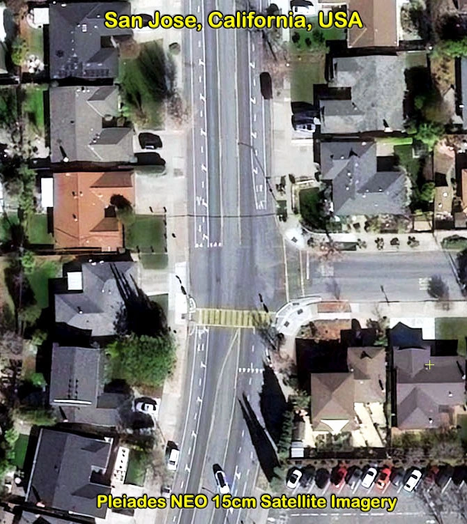
    Satellite images and GIS have become increasingly important tools for archaeologists, as these systems link information to precisely calibrated physical locations, and integrate information drawn from multiple sources. The usefulness of satellite imagery for identifying and analyzing archaeological sites was recognized from the early days of aviation and the imagery is now available from an array high resolution satellite sensors that provide even greater potential for investigating archaeological sites.

    View article on Stereo IKONOS Satellite Image Data Utilized to Support 3D Terrain Visualization for Mt. Ararat Anomaly in Turkey

    Anomaly on Mount Ararat, Turkey

    Anomaly on Mount Ararat, Turkey

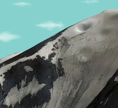
    IKONOS (0.81m) Stereo Satellite Image

    <1m Stereo IKONOS Satellite Image Data and 5m DEM

    (Image Copyright © DigitalGlobe and Processed by Satellite Imaging Corporation)

    View 3D Flythrough Movie

    Satellite Imaging Corporation (SIC) supplies satellite image data for visualization of terrain conditions in three dimensions (3D) or Digital Elevation Models (DEMs), which are generated from stereo satellite imagery. A digital elevation model can be used to closely examine various terrain attributes, their influence on the movement of soil and nutrients, as well as the resulting effect on forest, plant, and wildlife productivity and distribution.

    SIC provides specialized image processing technique by color balancing and utilizing the correct band combinations for Normalized Difference Vegetation Index (NDVI) mapping technique, our experienced imaging and GIS mapping team will isolate the terrain features and geological information needed for the correct analysis of your research project.

    Satellite Imaging Corporation is an official Value Added Reseller (VAR) of imaging and geospatial data products for:
    A Twenty First Century Aerospace Technology Value Added Reseller
    Satellite imagery can be applied within many industries. Please choose one to learn more.
    • Energy
    • Engineering and Construction
    • Defense and Security
    • Environmental Management
      • Global Climate Change
      • Urban Planning
      • Conservation
        • Archaeology
        • Coastal Management
        • Habitat Mapping
        • Wildlife Monitoring
      • Land Cover and Change Detection
      • Natural Disasters
      • Natural Hazards
    • Media and Entertainment
    • Natural Resources
    • Tourism
    GeoEye-1 WorldView-1 WorldView-2 Pleiades-1A QuickBird IKONOS SPOT-6 SPOT-5 RapidEye ASTER LANDSAT-7
    • Contact
    • Satellites
    • Gallery
    • Applications
    • Services
    • About
      • Terms of Use
      • Privacy Policy
      • Site Map

    Copyright © 2001-2017 Satellite Imaging Corporation. All rights reserved.

    Facebook Twitter LinkedIn